


Introduction
Unmanned aerial vehicles (UAVs) and automated guided vehicles (AGVs) are driving innovation in logistics, inspection, and industrial automation. A key requirement for these autonomous systems is obstacle avoidance—ensuring safe, efficient navigation in environments that can be dynamic and unpredictable.
While cameras and ultrasonic sensors are widely used, they often fail under challenging conditions such as low light, dust, or reflective surfaces. Millimeter-wave (mmWave) radar provides a reliable alternative: it penetrates fog, dust, and darkness, and performs consistently in both indoor and outdoor environments.
On the TI E2E forum (June 2025), developers working with the IWR6843 chipset demonstrated promising results for drone navigation. However, they also highlighted issues with clutter and multipath reflections inside warehouses, pointing to the need for advanced algorithms and sensor fusion.
Key Concepts
-
Drones (UAVs): Autonomous flying vehicles for inspection, mapping, and delivery.
-
AGVs (Automated Guided Vehicles): Robotic ground vehicles for warehouses, logistics centers, and factories.
-
Navigation Safety: The ability to detect and avoid obstacles in real time, even in complex and dynamic settings.
Technical Challenges
-
Clutter & Multipath
Metallic racks and concrete walls generate reflections, leading to false positives. Advanced filtering and machine learning models are needed to distinguish real obstacles. -
Real-Time Processing
Drones have limited onboard compute resources. Processing radar signals quickly without adding latency is critical for safe navigation. -
Energy Efficiency
Running radar continuously drains UAV batteries and reduces AGV duty cycles. Power-efficient radar modules and adaptive duty cycling are active research areas.
Applications & Case Studies
Powerline and Infrastructure Inspection
Drones equipped with mmWave radar can identify thin powerlines and transmission towers—even in poor weather—reducing the risk of collisions during inspection flights.
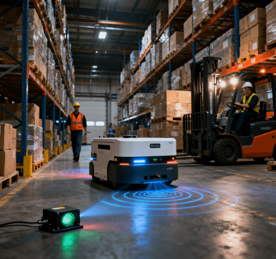
Smart Warehousing
AGVs rely on multi-radar sensor fusion to navigate around humans, forklifts, and shelves in warehouses. mmWave radar offers longer range than ultrasonic sensors and is less affected by lighting than cameras.
Community Insights
A Facebook robotics community (2025) user reported integrating a 60 GHz mmWave radar into a drone. In low-light warehouse conditions, radar-based navigation outperformed a camera-only approach.
💡 Learn more about radar applications in industry on Linpowave’s Applications page.
Sensor Comparison: Radar vs Other Technologies
| Technology | Strengths | Weaknesses | Best Use Cases |
|---|---|---|---|
| mmWave Radar | Works in low light, penetrates fog/dust, robust in cluttered environments | Lower resolution than LiDAR, sensitive to multipath interference | Drones, AGVs, safety-critical navigation |
| Cameras | High-resolution imaging, useful for object recognition | Poor performance in low light, affected by weather and glare | Visual classification, mapping, object tracking |
| Ultrasonic | Low cost, simple implementation | Very short range, poor accuracy in large or open spaces | Close-range detection, simple AGVs |
| LiDAR | High accuracy, detailed 3D mapping | Expensive, sensitive to weather, higher power consumption | High-precision mapping, outdoor navigation |
This comparison highlights why sensor fusion—combining mmWave radar with cameras and LiDAR—is becoming the industry standard for reliable navigation.
Future Outlook
The future of obstacle avoidance lies in multi-modal sensing and AI-driven interpretation:
-
Sensor Fusion: Radar + camera + LiDAR for comprehensive perception.
-
Edge AI: Onboard AI chips processing radar data in real time, reducing latency.
-
Miniaturization: Smaller, low-power radar modules enable integration into compact drones.
-
Fleet Collaboration: AGVs equipped with radar will coordinate with each other for efficient warehouse traffic management.
A recent IEEE study on UAV navigation reinforces that combining mmWave radar with vision sensors significantly improves safety and adaptability in unpredictable environments.
Conclusion
mmWave radar has emerged as a crucial enabler of obstacle avoidance in drones and AGVs. Despite challenges like clutter interference and energy consumption, ongoing advancements in algorithms, hardware, and AI-driven sensor fusion are making mmWave radar indispensable for autonomous systems.
As industries push toward fully automated logistics, inspection, and infrastructure monitoring, mmWave radar will remain at the heart of safe, reliable navigation.
🔗 Explore how Linpowave is shaping the future of mmWave radar technology: Linpowave Products.
FAQ
Q1: Why use mmWave radar instead of cameras?
A: Unlike cameras, mmWave radar does not depend on lighting and works in fog, dust, and darkness, ensuring reliable navigation.
Q2: Can radar fully replace LiDAR?
A: No. LiDAR provides higher resolution, while radar is more robust and cost-efficient. The best approach is combining both.
Q3: What is the detection range of mmWave radar?
A: Depending on module design, ranges can reach 10–50 meters, suitable for most drones and AGVs.
Q4: Does radar increase drone weight significantly?
A: Modern radar modules are lightweight (under 50 g), making them suitable for drones without major impact on flight time.
Q5: Which industries benefit most?
A: Warehousing, delivery logistics, infrastructure inspection, mining, and factory automation are leading adopters.