







Why fine-grained surface mapping matters now
Fine-grained surface mapping has moved from a specialist exercise to a practical requirement in surveying, civil works, and digital modeling. Engineers are no longer satisfied with a coarse outline of a site; they need to see subtle grade changes, curb edges, drainage paths, roof planes, and other small surface variations that affect design decisions. When those details are missed, the cost shows up later as rework, drainage problems, poor fit-up, or models that look right on screen but fail in the field.
That is why the conversation is shifting from “Can we map the area?” to “How much detail do we actually need, and how reliable is the data at that scale?” The answer depends on the application. A planning team may need a clean terrain model for early feasibility work, while a utility contractor may need sharper edge definition for infrastructure contour extraction and clash avoidance. In both cases, the value is the same: better decisions made sooner.
What buyers are really trying to solve
Most teams looking at fine-grained surface mapping are trying to reduce ambiguity. Surface data can be gathered quickly, but not all datasets tell the same story. A map that captures large forms well may still blur small transitions that matter for drainage, grading, access roads, or asset placement. For urban work, that gap becomes even more visible because roads, facades, retaining walls, and street furniture create dense, layered geometry.
That is where 3D urban modeling becomes useful, not as a buzzword but as a working method. A reliable 3D model can help planners compare alternatives, check clearances, and communicate site conditions across teams. The caution, of course, is that a model is only as useful as its source geometry. If the surface detail is too thin, the downstream outputs will inherit the weakness.
Key ways surface detail gets improved
There are several routes to sharper surface understanding, and the right one depends on the project scale, terrain complexity, and the kind of output the buyer needs.
Radar-assisted image correction
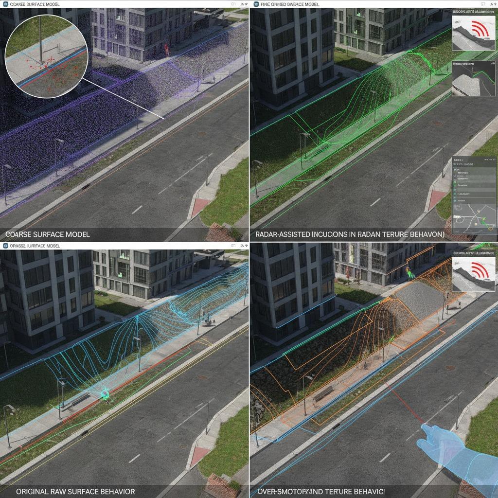
Orthophoto enhancement via radar is often discussed when teams need to strengthen image interpretation in difficult conditions. Radar can help reveal structure where optical imagery is limited by shadows, surface texture, or inconsistent lighting. Used carefully, it can support cleaner feature recognition and improve the usefulness of imagery for mapping workflows. It does not replace good field practice, and it is not a magic fix for every scene, but it can improve the confidence of the map when paired with other data sources.
Feature-to-feature alignment
Terrain feature matching is another practical step. Instead of relying on a single broad surface fit, the workflow looks for common features across datasets and aligns them more precisely. This matters in mixed environments, such as roadside corridors or construction zones, where recognizable edges, slopes, and landmarks anchor the model. The method can improve consistency, though it also demands careful quality control. Weak control points or noisy source data can lead to a map that appears precise while actually drifting from reality.
Contour-focused extraction
For buyers working in infrastructure, infrastructure contour extraction is often the bridge between raw surface data and usable design files. Clear contours help engineers understand elevation changes, drainage behavior, embankments, and cut-fill implications. The practical benefit is not just cleaner drawings; it is faster decision-making. Teams can identify problem areas earlier and avoid overcomplicating later stages of design.
How to choose the right approach
Start with the end use. If the project is early-stage planning, a moderate level of detail may be enough. If the output will support grading, drainage, utilities, or asset positioning, the tolerance for missing detail drops quickly. Ask how the data will be consumed: by GIS staff, design engineers, contractors, or city planners. Each group needs a slightly different balance of resolution, interpretability, and file handling.
Also consider the site itself. Flat sites can hide small but important elevation changes, while steep or built-up areas often require richer surface definition. In urban zones, shadows, occlusions, and mixed materials can complicate interpretation, so a single-source workflow may be risky. A layered approach usually works better, even if it takes a bit more coordination.
Common mistakes that slow projects down
One recurring mistake is asking for detail without defining what detail means. Another is assuming a visually sharp map is automatically a dependable one. A polished output can still miss the very edge that matters for a retaining wall or curb line. Buyers should also be wary of overprocessing. Excessive smoothing can make models look elegant while stripping out the terrain behavior engineers actually need.
There is also a budget trap. Teams sometimes focus on the capture method and ignore the downstream effort needed for cleanup, matching, and validation. That is where real time is spent. A slightly more thoughtful workflow at the start often saves much more time later.
Practical buyer advice
If you are specifying a project, ask for sample outputs that reflect the actual site type, not a best-case demo. Check how the workflow handles edges, transitions, and mixed surfaces. For urban and infrastructure work, look closely at whether the model preserves the features that designers will need, not just the ones that look good in presentations.
It also helps to define acceptance criteria in plain language. What surface features must be visible? Which areas are critical? Where can the model be approximate, and where can it not? Those questions keep procurement grounded in project reality instead of abstract performance claims.
A useful next step
For engineering teams, the smartest move is usually to connect the mapping method to the decision it must support. Fine-grained surface mapping is not valuable because it is detailed; it is valuable because it reduces uncertainty in design, construction, and asset planning. If your current workflow is producing maps that look acceptable but leave too much interpretation to the field team, it may be time to tighten the capture, matching, and extraction steps before the next project starts.