


Introduction: The New Challenge of Drone Flight Safety
Obstacle avoidance and altitude measurement have always been critical for drones, especially at low altitudes. Traditionally, drones rely on ultrasonic sensors or visual cameras for environmental perception. However, in dim lighting, dust, or light rain and fog, these sensors often struggle to provide stable and accurate data.
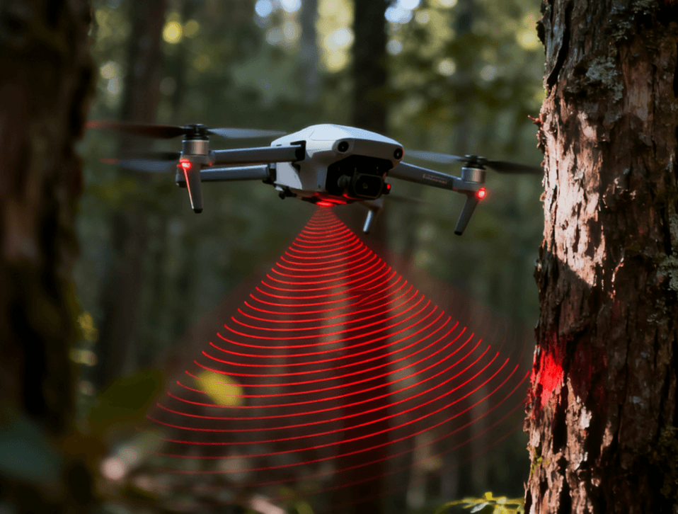
During a test flight in a dense forest, our engineering team noticed that the conventional vision system exhibited delays when navigating through tightly spaced trees, occasionally resulting in minor collisions. This was the moment when millimeter-wave (mmWave) radar proved its advantage: it can penetrate smoke, fog, and low light, offering centimeter-level distance and velocity measurements—essentially giving drones “eyes and brain” for precise environmental awareness.
1. Principles and Advantages of mmWave Radar
mmWave radar works by transmitting electromagnetic waves in the 60–81GHz frequency range and receiving reflected signals to measure distance, velocity, and angle. Its core advantages include:
1.1 Robust Environmental Adaptability
Unlike optical sensors, mmWave radar is minimally affected by lighting, dust, or temperature fluctuations. It provides accurate measurements even at night or in fog.
According to TI: Understanding mmWave Radar Fundamentals, mmWave radar can maintain measurement accuracy within ±5 cm under low-visibility conditions.
1.2 High Precision and 3D Perception
Using FMCW (Frequency Modulated Continuous Wave) technology, the radar can simultaneously capture target distance, speed, and angle, enabling full 3D awareness.
For example, when a drone flies through a densely wooded area, the radar can detect branch positions within milliseconds, allowing the flight path to adjust proactively.
1.3 Lightweight and Low Power Consumption
Modern mmWave modules are compact and energy-efficient, imposing minimal weight on the drone while supporting prolonged operation without reducing flight time.
2. Obstacle Avoidance: The Drone’s “Invisible Shield”
2.1 3D Dynamic Obstacle Avoidance
mmWave radar can track not only the position but also the velocity and angle of objects. This enables drones to anticipate moving obstacles rather than merely avoid stationary ones.
In a test scenario, Linpowave’s U200A radar successfully predicted a bird crossing the drone’s path and adjusted altitude in advance, preventing collision.
2.2 Radar and Vision Fusion
Advanced drones typically adopt a “radar + vision” dual-sensing strategy:
-
Radar: Long-range detection for obstacle presence
-
Vision: Detailed recognition of object shapes and material
This combination ensures safe and stable flight even in complex environments.
Explore Linpowave’s UAV Radar Modules, validated on multiple commercial drones using this fusion approach.
3. Altitude Measurement: From Barometers to mmWave Radar
3.1 Limitations of Traditional Sensors
Ultrasonic sensors and barometers are vulnerable to environmental factors, causing altitude drift. This is particularly evident in mountainous areas or urban landscapes with dense buildings.
3.2 Precision Altitude with mmWave Radar
mmWave radar measures the distance between the drone and the ground in real time, unaffected by terrain variations or surface materials.
Linpowave’s UAV Altitude Measurement Module outputs stable data with a minimum resolution of 0.05 m, allowing drones to maintain precise height even during low-altitude operations.
3.3 Application Scenarios
-
Low-altitude agricultural spraying: precise control of spray height
-
Industrial inspections: safe navigation along power towers and lines
-
Aerial surveying & mapping: stable imagery and accurate perspectives
4. System Integration and Optimization
4.1 Power and Antenna Design
Limited drone power requires a balance between consumption, sensitivity, and field of view. Linpowave adopts compact antenna array designs to maximize horizontal coverage while minimizing energy usage.
4.2 Signal Filtering and Algorithm Enhancement
Low-altitude radar signals may be disturbed by ground reflections. Incorporating Kalman filters and clustering algorithms improves measurement stability and ensures real-time obstacle avoidance.
4.3 Flight Controller Integration
Using standard CAN or UART interfaces, radar data can reach the flight controller with latency under 10 ms, enabling instantaneous decision-making.
5. Industry Trends and Future Directions
According to MarketsandMarkets, the mmWave radar market in drones has a CAGR of over 25%.
Key future directions include:
-
Multi-radar array fusion for all-around obstacle detection
-
AI-powered target recognition and flight path optimization
-
Lightweight integrated chip modules for longer endurance
As costs decrease, mmWave radar is expected to become a standard feature in consumer and commercial drones, making autonomous obstacle avoidance widely accessible.
6. FAQ: Common Questions About Drone mmWave Radar
Q1: What advantages does mmWave radar have over ultrasonic or vision sensors?
A1: mmWave radar remains stable in low light, fog, dust, and even rain or snow. Ultrasonic sensors are easily affected by noise, while visual cameras can fail in low-light or obstructed environments. Additionally, mmWave radar can simultaneously measure distance, velocity, and angle, enabling 3D dynamic perception and improving drone obstacle avoidance accuracy.
Q2: Will adding mmWave radar increase drone payload or reduce flight time?
A2: Modern mmWave radar modules are compact, lightweight, and energy-efficient. Optimized designs have minimal impact on drone endurance or payload. For example, Linpowave’s UAV radar modules consume only tens of milliwatts while providing continuous, stable operation.
Q3: Can mmWave radar completely replace vision systems?
A3: Not entirely. Radar excels at coarse distance and velocity detection, ensuring safety in complex environments, while vision systems identify object shapes, textures, and colors. The optimal approach is radar + vision fusion, achieving high-precision perception across all scenarios.
Q4: Can mmWave radar measure drone altitude?
A4: Yes. mmWave radar measures the distance between the drone and the ground in real time, unaffected by terrain changes, lighting variations, or wind. Linpowave’s UAV altitude measurement module provides a minimum resolution of 0.05 m, ideal for low-altitude operations or precision agriculture.
Q5: What are typical applications of mmWave radar on drones?
A5:
-
Low-altitude agricultural spraying: precise control of spray height
-
Industrial inspections: safe navigation along power towers and lines
-
Aerial surveying & mapping: stable imagery and accurate perspectives
-
Research and test flights: evaluating flight strategies in complex environments
Q6: How can mmWave radar be integrated with a drone flight control system?
A6: Modern radar modules offer standard interfaces like CAN or UART, allowing fast integration with flight controllers. Data latency is typically under 10 ms, providing real-time distance, velocity, and angle outputs for obstacle avoidance and altitude control.
Conclusion: Giving Drones True Perception
mmWave radar empowers drones with genuine environmental awareness. From dynamic obstacle avoidance to precision altitude measurement, it transforms drones into intelligent, aware flying machines.
Explore more drone radar solutions:
-
Related technical blog: Fundamentals of mmWave Radar: From FMCW to Target Detection