


Overcoming Imaging Limitations in Remote Sensing with Synthetic Aperture Radar (SAR) Imaging
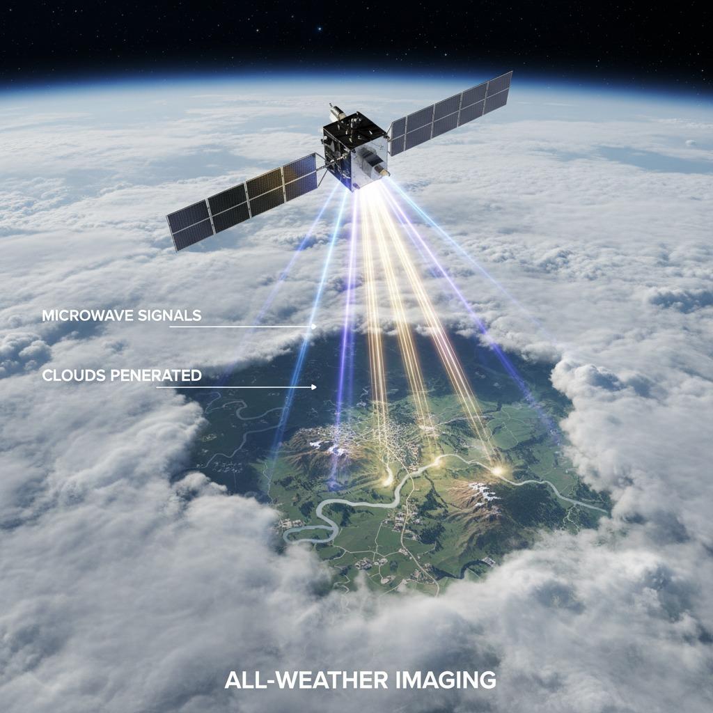
In the field of remote sensing, professionals often face significant challenges when trying to capture high-quality images of Earth's surface, especially in adverse weather or darkness. Traditional optical imaging systems fall short due to their dependence on visible light, leading to incomplete data collection and unreliable results. Synthetic aperture radar (SAR) imaging emerges as a powerful solution, utilizing microwave signals to penetrate clouds and operate day or night, providing consistent and detailed imagery. This technology addresses these core problems by enabling all-weather, all-time monitoring, which is crucial for applications like environmental surveillance, disaster management, and military reconnaissance.
Enhancing Range Resolution for Precise Distance Measurements
One of the primary hurdles in radar systems is achieving fine range resolution, which determines how well targets at different distances can be distinguished. Poor range resolution results in blurred images where closely spaced objects merge, complicating analysis. Synthetic aperture radar (SAR) imaging tackles this by employing wide bandwidth signals and advanced signal processing techniques, such as pulse compression, to sharpen the resolution down to meters or even centimeters. For instance, by optimizing the chirp rate in transmitted pulses, SAR systems improve the ability to separate echoes from nearby scatterers, ensuring that features like urban infrastructure or terrain variations are clearly delineated. This enhanced range resolution not only boosts the accuracy of topographic mapping but also supports real-time decision-making in dynamic scenarios, reducing the risk of misinterpretation in critical operations.
Improving Angular Resolution to Capture Fine Spatial Details
Angular resolution presents another challenge, where limited beamwidth in conventional radars causes overlapping returns from objects at similar ranges but different angles, leading to distorted spatial representations. This issue is particularly problematic in complex environments like forested areas or coastal zones. Synthetic aperture radar (SAR) imaging resolves this through its unique aperture synthesis method, simulating a much larger antenna by moving the radar platform, such as on an aircraft or satellite. As the platform travels, multiple echoes are coherently combined to form a high-resolution image, achieving angular resolutions far superior to physical antenna limits—often sub-meter levels. Techniques like spotlight SAR further refine this by focusing the beam on specific areas, allowing for detailed imaging of intricate structures. By solving angular resolution constraints, SAR enables the detection of subtle changes, such as vegetation health or infrastructure damage, providing actionable insights that traditional methods cannot match.
Generating Dense Point Clouds for Comprehensive 3D Modeling
A common pain point in imaging technologies is the sparse data output, which hinders the creation of robust 3D models needed for volumetric analysis or simulation. Sparse point clouds lead to incomplete reconstructions, affecting everything from urban planning to geological surveys. Synthetic aperture radar (SAR) imaging counters this by producing dense point clouds through interferometric SAR (InSAR) and polarimetric processing, where phase differences and scattering properties from multiple passes generate millions of data points. This density allows for accurate elevation mapping and deformation monitoring, even over vast regions. For example, in earthquake response, dense point clouds from SAR can quickly model ground shifts, aiding in rescue efforts. The technology's ability to integrate with LiDAR or optical data further enriches these models, offering a holistic view that sparse alternatives simply cannot provide.
Reducing False Alarm Rates for Reliable Detection
False alarm rate reduction is essential yet often overlooked, as high false positives from noise or clutter can overwhelm analysts and erode trust in the system. In radar imaging, environmental interferers like rain or sea clutter frequently trigger erroneous detections, complicating target identification. Synthetic aperture radar (SAR) imaging addresses this through sophisticated algorithms, including adaptive filtering and machine learning-based classifiers that distinguish true targets from artifacts. By incorporating multi-look processing and statistical modeling of speckle noise, SAR minimizes false alarms while preserving detection sensitivity. This results in cleaner images with lower error rates, crucial for applications like border security or wildlife tracking. Ultimately, these advancements ensure that SAR not only solves visibility issues but also delivers dependable, high-fidelity data for informed decision-making.
By integrating these solutions—superior range resolution, enhanced angular resolution, dense point cloud generation, and effective false alarm rate reduction—synthetic aperture radar (SAR) imaging transforms remote sensing from a weather-dependent endeavor into a reliable, versatile tool. Its adoption continues to grow, empowering industries to overcome longstanding obstacles and unlock new possibilities in data-driven exploration.