


The need to keep utility infrastructure—power grids, pipelines, wind farms, and solar arrays—safe and working is important. Old inspection methods have big problems: high risks, high costs, and low efficiency. Drones are changing things. They are fast, accurate, and can hold many sensors, making them the main tool for digital change in the utility sector. They change how data is taken, risks are judged, and fixes are planned.
I. Drones' Great Value in Utility Inspection
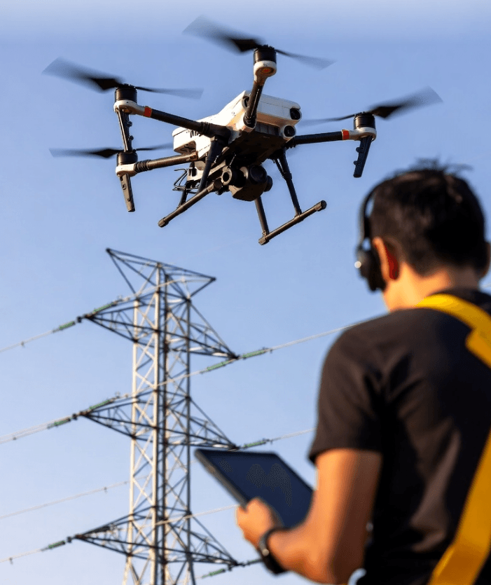
Drones give utilities big benefits, especially in safety and speed.
Old inspection work was dangerous. Workers climbed towers or walked on bad ground. Drones stop this risk. They use cameras and thermal sensors to check things close up, but from far away. This keeps workers safe. Because of this, companies spend less on safety measures. They can move skilled workers to focus on fixing and planning instead.
Drones also save time and money. Helicopters are fast, but cost a lot. Foot checks are slow. Drones are the best choice. One drone can check many towers or kilometers of pipe in a single day. This is much faster than people. Also, after bad storms or earthquakes, drones are the first to check damage. They quickly tell repair crews what to do, which helps bring power back fast.
Drones also make data better. They use 4K cameras, thermal cameras, UV sensors, and LiDAR (Light Detection and Ranging). Data changes from just seeing a problem to knowing exactly how bad it is. For example, thermal cameras measure hot spots on power lines. This tells planners if a problem is urgent. LiDAR makes 3D models of equipment. These models give exact numbers to manage trees near power lines.
(Learn more about LiDAR integration in UAVs from NASA UAS research.)
II. AI and Big Data: Making Drone Data Useful
Drone data is most useful when you mix it with Artificial Intelligence (AI) and big data tools. This system—air, cloud, and smart tools—is making utility management better.
AI finds and labels problems in the data right away. Old analysis took many hours. Now, AI models look at the pictures and quickly find things like missing bolts or damaged equipment. The AI sorts the problems and gives them a score.
AI also helps predict when things will break. It looks at drone data over time, like thermal pictures from different months. It sees small changes, such as metal getting rustier or a hot spot getting hotter. This analysis helps plan maintenance. Utilities can fix things before they break. This saves money and stops outages.
Also, LiDAR data is used to build Digital Twins. These are exact digital copies of equipment. AI works with these copies. Managers can test repairs in the computer and see what happens in a storm. The system then decides which broken part needs to be fixed first, based on how important it is.
(Read about Digital Twin applications for infrastructure from IBM.)
III. Millimeter-Wave Radar: Checks in Any Weather
Drones mostly use cameras and LiDAR. But these sensors don't work well in fog, rain, or smoke. To check things all the time, utilities need a sensor that works in bad weather: Millimeter-Wave (mmWave) Radar.
mmWave radar uses high-frequency waves (30 to 300 GHz). These waves can go through fog, rain, dust, and smoke. Putting this radar on drones helps in new ways.
First, it helps drones fly safely in bad weather. The radar gives exact distance and speed data. This is key for Beyond Visual Line of Sight (BVLOS) flight. It makes sure the drone does not hit thin power lines or towers when visibility is low.
Second, mmWave can see under the surface of some materials. This helps find problems that cameras can't see. For instance, it can check wind turbine blades for water or cracks hidden under the paint. This helps find problems early.
Last, mmWave can measure very tiny movements. It can check the small shakes of power lines in the wind. Or it can check tower parts for tiny bending. This gives new data to guess when a structure might fail.
Mixing mmWave radar with cameras and LiDAR makes a very reliable sensor system. This system will keep utility networks strong and safe in all conditions.
(See how Linpowave’s industrial mmWave radar enhances drone sensing for harsh environments.)
Frequently Asked Questions (FAQ)
Q1. What is BVLOS flight, and why is it important for drone checks?
BVLOS means Beyond Visual Line of Sight. Drone checks often need to go very far, past where the pilot can see. BVLOS allows drones to fly these long routes by themselves. This makes inspection much faster.
(Refer to FAA’s BVLOS guidelines on faa.gov.)
Q2. How does AI make drone data good?
AI makes data good by checking it and making sure it's consistent. The drone's flight program makes sure all pictures are taken at the same angle. The AI then processes this data. This lets people compare pictures taken months apart and see small changes.
(Learn how Linpowave integrates AI-based radar data processing.)
Q3. What do companies spend money on first when starting a drone program?
Money is spent on three main things: high-quality drones (they must fly long and carry heavy sensors), expensive sensors (like industrial LiDAR and thermal cameras), and the software that uses AI to study the data.
Q4. How does AI help plan fixes for utility systems?
AI helps by looking at the thermal and visual drone data over time. It sees which parts are slowly getting worse. The AI then guesses when a part will break. This lets the company fix the part before it fails.
(Read related case studies from Energy.gov).
Q5. How does mmWave radar make drones safer near power lines?
mmWave radar gives very exact distance data. It is an extra safety system. It can see thin wires and other things the drone might hit. This keeps the drone safe when it flies very close to power lines, even in bad weather.
(Discover Linpowave’s 4D radar technology for UAVs.)